Adding or changing elements in a map
Editing tool
To operate on a specific map, just click on the "Edit map" link in the "My Maps" page.
Left side tools
 Navigation and positioning
Buttons marked with "plus" and "minus" allow to zoom in and out.
The third button is used for positioning in the initial launch view.
 Initial position and background map
Using this tool allows you to register or change at any time the initial position, zoom and background map of the current view on the screen. From now on this will be the appearance of the map at start-up, until you change it.
 Geolocation
A tool that enables geolocation in real time (via GPS if available). Once activated, it repositions the view at each detection showing a circle with tolerance at estimated accuracy.
 Distance measurement
A tool to measure distances on the map.
 Marker category list
Markers are grouped in categories. With this tool you can analyse the entire list in each category and point on a single marker.
 Search
A tool to perform a selective search of all the elements of the map with autocompletion. The search is extended to global online results.
 Selection panel
A tool to select map elements using list divided into groups, categories and types (marker and vector). It is possible to simultaneously select all the present marker elements, or selectively elements for each group. Vector elements are selected individually.
Tracking tool
The tracking tool is located at the top right and is equipped with the following buttons:
 A tool to track a path
 A tool to draw a polygonal area
 A tool to draw a rectangle
 A tool to draw a circle
 A tool to place a marker
After selecting one of the instruments of the tool, just follow the related signs that automatically appear in the selected mode.
Similarly, to end the operation proceed as indicated for each instrument.
Assignment of groups and categories
A panel opens automatically at the end of each operation performed with the tracking tool. Its purpose is to determine group and category.
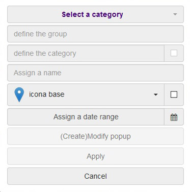 If data is of a marker type, it allows you to select or enter new groups/categories. Next to the category name, there is a check box to specify whether the selected category will be immediately visible when the application starts.
You must enter a name for the new element in the text box.
You can then select an icon from a pre-defined group or from one of the icons uploaded specifically by the client (only commercial version).
The check box beside the icon is used to assign a label which will then be visible in the vicinity of the element while viewing the map. This label will show the name of the item.
In the field below you allocate a start date and an end date to the item (for example to geolocate a series of events).
The marker will not be visible in the public map if the current date is outside the parameter range.
Through the "(Create) Edit popup" button you can give a description to an item. This description can contain text, images or multimedia elements. Its compilation takes place via an html editor described further on.
If you want to save the changes without attaching a description, just click the "Confirm" button.
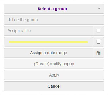 If data is of a vector type (path, polygonal area, rectangle, circle) the panel is similar to that for the markers, but with certain differences.
First of all, you can select and insert only a group, not a category.
The check box to indicate whether the item will be visible at start-up is located next to the name.
In place of the field for the icon, there is a selector to specify colour, thickness and stretch of the line.
In case of an imported multiple element (button "Import file"), it will not be possible to assign a description with the exception of multiple vector elements composed of lines only or of lines and markers.
Other fields are identical to the ones in case of markers.
HTML editor
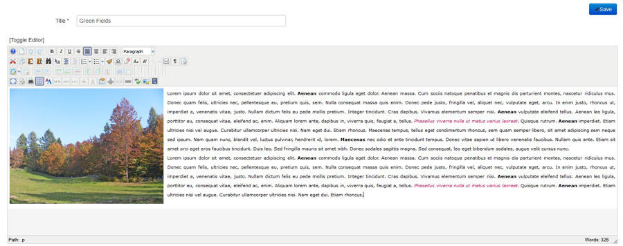
It is an html WYSIWYG (What You See Is What You Get) editor equipped with all available options. It is equipped with a comprehensive user manual. After quick gaining of experience its use becomes increasingly efficient. Having completed the task of creating/editing the content, press Save and the update/change will become immediately operational.
Users familiar with html language and css styles can use the "Toggle editor" button in the top left to enter the html code directly. In order to compile the content, you can use class names added to the appropriate "Custom css styles" field of the map (button "Edit settings" on the map list page).
Change and remove
 A tool to edit a marker
With this tool, you can edit the selected item after the activation.
In case of a marker, you can proceed to its repositioning. If it is a vector, it will be possible to operate a selective modification for each vertex (excluding complex geometries), or size and positioning in case of circles and rectangles.
After confirmation via the automatic activation of the panel shown previously, we proceed to the possible replacement of name, icon, or to modify the thickness and colour of dates.
In case of multiple imported elements, you can change the icon that will affect all the markers associated with the individual element. The same applies to a vector.
 A tool to delete an element
This tool eliminates a selected element. In case of an imported multiple element, you will be asked whether to proceed with the elimination of all markers associated with the individual element or only of the selected one, or the selected vector or an element complete with any possible attached marker.
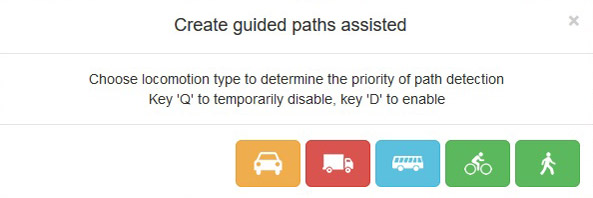
Assisted guided routes
 This powerful tool allows you to draw in automatic and assisted way a route along a road, a track or a path present in the background map, choosing the appropriate typology. The purposes may be many, e.g. obtaining a defined path for a sports competition.
Various operations of editing and deletion are available during tracking at the same time for maximum freedom of action in the use of the tool. At the end of this operation a panel will appear in order to set save parameters, as in previous operations.
Data import and export
 Import tool allows you to import a file in the following formats: KML, KMZ, GPX, GeoJSON and Shapefile (zip). This operation is also possible through the convenient drag & drop function directly on the map.
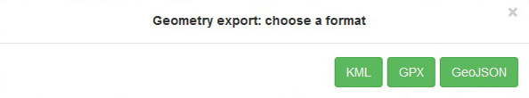
In terms of export, after selecting an item to be exported, it is then available to be saved in the desired format of your choice: KML, GPX and GeoJSON.
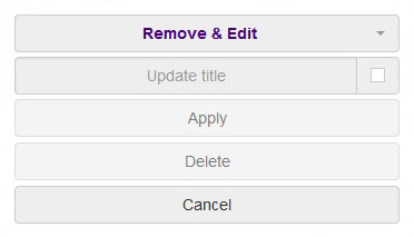
Change/delete menu
 With this tool, you can change the name of a group or category, and change the parameter that determines the visibility of the start-up of a category.
Moreover, the tool allows the elimination of a group and all of its contents (categories, markers, vectors) or of a category and all of its contents (markers).
To remove an individual vector element, use the tool that eliminates the element by direct selection.